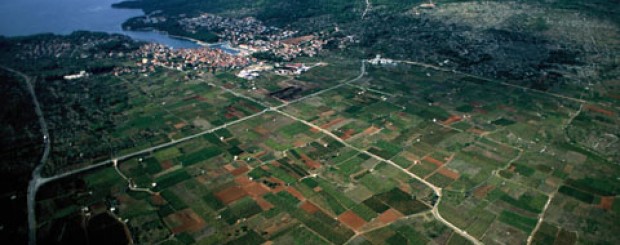
Old town plain-UNESCO heritage
The large plain occupies the island’s central area. Its name kept changing with the successive arrival of masters. First known by the Greeks as chora Pharu, it became Ager Pharensis in Roman times, to be replaced by the medieval name of Campus Sancti Stephani (the Field of St.Stephen). It is now known as Stari Grad Plain. It has sustained the life on the island for thousands of years.
The Plain is in fact a cultured landscape, formed by thousands of years of human labour. Its ancient man-made features originate from 24 centuries ago when Greek colonist divided the Plain into rectangular plots of 1×5 stadia, (ca.180x900m), each fenced in with drywall. The Plain was crisscrossed with major roads cutting through it in regular longitudinal and transveral directions. Today we can identify the point in the Plain, located at a road intersection, from wich the Greek surveyor began his measuring. The point is situated near Dračevica, a pond in the Plain.
The name of one of the large plot owners from Greek times is known Mathios, (son) of Pithaes, had his name carved into the boundary stone, now kept in the Museum of Archeology in Zagreb. In the area of Kupinovik, below Dol, the land was first owned by Komon, (son of) Filoksenido, and later by a Roman, Gaius Cornficius Carus, town councillor of Pharia who built there a large manor house.
Remains of dozens of villae rusticae were found in the Plain. In the course of the long Roman Peace the Plain was well-organised system of large and wealthy estates with numerous prosperous farm holdings. In the Middle Ages the Plain continued to be farmed. The Statue of Hvar from 1331 speaks of an ancient road (via antiqua) running through the Field of St Stephen. The roads remained in use thanks to the continuous farming.
From the Middle Ages onwards, the large land holdings were cut up into smaller plots, with the present-day boundaries inside the great ancient estates standing witness to the changes and centuries gone by. The Statute recorded the Slav-descended vineyard owners. Boljša, Desislav, Gojmir, Grdoš, Grubša, Hranko, Hvališa, Premil, Prvoš, Vltoš, Vukodrug, etc., prove that Slavs took over completly the Roman Pharia, making Hvar a truly Croatian island in the Middle Ages.
The oldest villages on the island of Hvar lie at the Plain’s southern edges, Dol Sv. Marije and Dol Sv. Barbare are situated in the fertile valleys and brought together by the parish church of St.Michael the Archangel on the hill. Vrbanj was the home of folk leader Matija Ivanić. On the Plain’s east rim lies Vrboska, build in the 15th century as Vrbanj’s port. On the north-facing hills are nameless scatterings of houses, in fact hamlets inhabited temporarily by people of Vrbanj working the land or grazing their livestock.
For centuries, Stari Grad Plain has been covered with vineyards, and in the course of Antiquity and the Middle Ages people also grew wheat. Fig trees grew at plots edges and in less fertile zones. Almond trees were planted nearer to the settlements, almost touching the gardens. Olive groves, than as today, covered the low hills surrounding the Plain. Carob trees grew among the olive trees. Still higher lay, until quite recently, terraced fields of lavender. Now, Aleppo pines are slowly taking over the terraceland and gradually descending to the edges of the settlements.
Stari Grad plain and the Historic centre of Stari Grad were incscribed on UNESCO List of the World Heritage sites on July 8th, 2008. Since than Stari Grad Plain is managed by Stari Grad Plain Agency.


